| |

Smooth MODIS Images | |
|
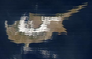
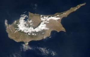
Near real-time images from NOAA's Terra and Aqua Earth Observation Satellites are available for download from http://lance-modis.eosdis.nasa.gov/cgi-bin/imagery/realtime.cgi at resolutions of between 4 kilometres per pixel and 250 metres pre pixel. By far the most interesting are the 250 m/pixel and 500 m/pixel images. But there is one major problem. Because of the manner in which the MODIS instrument scans the Earth's surface, in swaths, only the centre two-thirds of these images render sharply. As the Earth curves away from the satellite towards the eastern and western horizons, the data in the swaths becomes compromised. This results in some of the detail in adjacent swaths being duplicated at the edges of the image. If a region of interest lies close to the edge of an image it can be grossly distorted, as shown in the upper image of Cyprus. What Smooth MODIS does is to realign the data in MODIS images to rectify this problem as far as is possible. The lower image illustrates the improvement that can be achieved. SmoothMODIS now offers a new option: to geometrically rectify the image before saving. The new options in the Save Menu stretch the image laterally to compensate for foreshortening in the view from satellite.
Download Smooth MODIS v 1.50 (650 kB) - (Updated November 2014) Double-click on the smoothmodis-setup.exe file to install the program, which also includes a segment from a MODIS image, for evaluation purposes.
This page has been accessed |
Please e-mail your comments to
|